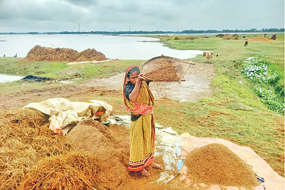
Bangladesh requires approximately 4.24 crore metric tonnes of rice annually. A significant portion of this supply is produced during the Boro season, which alone contributes nearly 60 per cent of the national “grain store”. Of this Boro output, around 20 per cent originates from the haor wetlands. In Sunamganj district alone, about 6 lakh metric tonnes of paddy are contributed to the national food reserve after retaining a portion for local consumption. However, seasonal rainfall between Falgun and Baishakh has increasingly submerged these critical wetland “grain baskets”, disrupting harvesting and post-harvest processing.
The north-eastern haor basin, spread across seven districts and covering roughly one-sixth of the country, plays a vital agricultural role. In the current Boro season, paddy cultivation covered approximately 9.63 lakh hectares. Yet, a significant share of crops remains unharvested, while already-cut paddy cannot be properly dried. In many locations, germination has begun on threshing floors, accompanied by signs of spoilage due to prolonged moisture exposure. In response, the government recently announced three months of assistance for affected farming households, while public procurement of paddy and rice in haor regions is scheduled to begin from 15 May.
Key agricultural and rainfall indicators
| Indicator |
Figure |
| Annual rice demand (Bangladesh) |
4.24 crore metric tonnes |
| Boro contribution to national grain stock |
~60% |
| Haor contribution to Boro production |
~20% |
| Sunamganj contribution to national stock |
~6 lakh metric tonnes |
| Boro cultivation area in haor region |
9.63 lakh hectares |
Recorded rainfall and flooding events
| Year/Date |
Location |
Rainfall/Event detail |
| 1959 (19 June) |
Sylhet |
336 mm rainfall |
| 2000 (12 June) |
Sylhet |
362 mm rainfall |
| 2017 (April) |
Haor region |
Early flash floods inundated crops |
| 2022 (June) |
Sunamganj/Sylhet |
90% and 80% areas submerged respectively; 17 June recorded 282 mm rainfall |
| 2024 (9 June) |
Sylhet |
220 mm rainfall within hours |
| 2026 (27 April) |
Sunamganj region |
76–205 mm rainfall across locations |
The haor ecosystem, spanning approximately seven districts in the north-east, has long been shaped by complex hydrological cycles. It is not merely a production zone but also a deeply interlinked ecological and cultural landscape. The current crisis, however, cannot be interpreted through simplistic or binary frameworks. Instead, it must be understood within a long-term historical interaction between natural processes and human interventions.
Structural dimensions of the haor crisis
Three interlinked layers of structural pressure are evident in the haor region. The first is local in nature, involving land boundary disputes, illegal leasing practices, encroachment-driven trade, and governance challenges linked to infrastructure projects and local patronage networks.
The second layer concerns state policy and institutional management. Agricultural planning, wetland governance, biodiversity conservation, waterbody regulation, and infrastructure development have often operated in fragmented ways. Administrative interventions, including embankment construction and resource extraction, have contributed to ecological disruption.
The third layer is transboundary. Environmental changes in upstream Indian states such as Meghalaya and Assam—including deforestation, mining activities, dam construction, and hydropower projects—affect river flow dynamics. These factors, combined with global climate variability, have intensified hydrological instability in the haor basin.
Hydrological variability and local knowledge
The haor region experiences three distinct forms of flooding: seasonal monsoon flooding, flash floods caused by upstream hill runoff, and unseasonal rainfall-induced waterlogging. The latter, locally referred to as “kacchira bochor”, has become increasingly frequent in recent years. This condition delays rice maturation and increases crop vulnerability.
Traditional forecasting systems, including proverbs and oral ecological knowledge, historically provided early warning signals. However, many of these have weakened in influence compared to institutional forecasting systems. Local observations suggest rainfall patterns are increasingly arriving from atypical directions, further complicating agricultural planning.
Agricultural practices and economic pressures
Field-level accounts indicate that many farmers depend heavily on loans for cultivation. The cost of cultivating one kani of land can reach approximately 15,000 taka, while yields often range between 20 to 25 maunds. With official procurement prices remaining low, farmers frequently face minimal or no net returns. This economic imbalance has intensified calls for revised procurement pricing.
Modern high-yield rice varieties dominate current cultivation, replacing traditional flood-resilient strains. However, these newer varieties often show reduced tolerance to prolonged inundation and irregular rainfall patterns. Historically, deepwater rice varieties were developed locally, offering greater resilience to flooding conditions.
Infrastructure and sedimentation concerns
Large-scale embankment and infrastructure development, including repeated earthworks for crop protection embankments, has altered natural water flow. Between 2023 and 2026, more than 2,136 embankment-related projects reportedly used over 93 lakh cubic metres of soil in Sunamganj alone. Such interventions have contributed to sedimentation in rivers and wetlands, reducing water-holding capacity.
Experts and practitioners have repeatedly emphasised the need for systematic dredging and restoration of rivers, canals, and wetlands to restore natural hydrological balance.
Conclusion
The recurring inundation of haor croplands reflects a combination of ecological, institutional, and transboundary pressures. Addressing these challenges requires coordinated planning across ministries, integration of local ecological knowledge with scientific forecasting, and long-term restoration of wetland hydrology.


Comments